
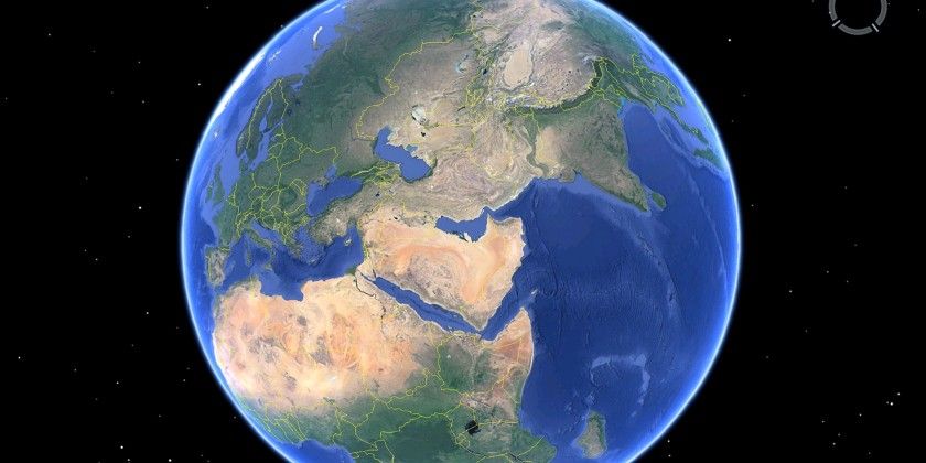
Google Earth (and Google Maps) is the easiest way to get a satellite view of your house and neighborhood.
The virtual globe of Google Earth combines satellite imagery, maps, aerial photos, and of course the Google search engine. This gives us a fascinating application that enables anyone to view nearly any part of the world and get instant geographic information for that area.
Google Earth used to come in Free and Pro flavors, but Google Earth is now completely free to download on desktops, and you can even use it in the Chrome web browser and on Android or iOS. In this article, we’ll show you how to take advantage of Google Earth’s high-resolution graphics and satellite images.
Google Earth Satellite View vs. Google Maps
Google Earth and Google Maps use the same satellite/aerial and street view imagery to give you some amazing data on our planet. Few things like searching, and directions are also similar in both.
But there are important differences too.
Google Earth is a 3D virtual globe while Google Maps is used more like a 2D map even though it has 3D features. Also, Google Maps is a more powerful local tool. Google Maps allows you to find and share directions and explore your locality with a fine-toothed comb. It also keeps this information synced across all your devices.
Google Earth and its satellite imagery may look the same when you compare it with Google Maps. Both have the satellite layer. But it offers an important distinction: a better set of Layers.
Thanks to the Voyager feature inside Google Earth, you can explore interesting cultures and our planet’s nature in all its glory.
In short: When you want to go from Point A to Point B, use Google Maps. When you want to explore the world in all its high-resolution 3D glory, use Google Earth.
Launch Google Earth for some fun virtual trips, and then tap into its many practical benefits.
1. View Your House With Google Earth
The virtual trips allow you to visit any country on Earth. But you will still go on it to find your own house. You can fly down from outer space and zoom down to the street level.
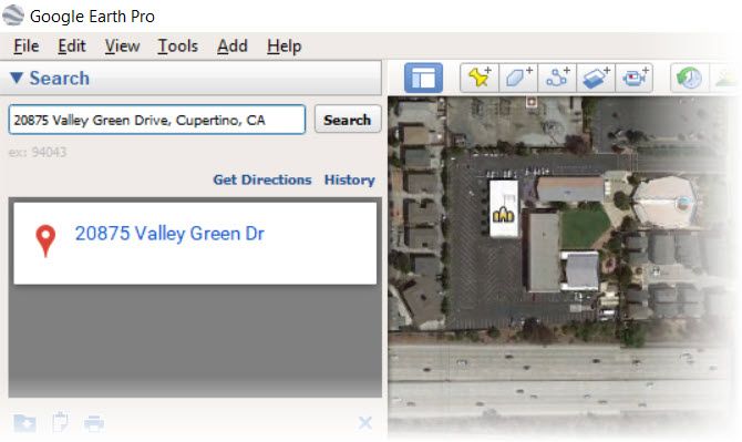
To find your own house:
- Go to the search box on the top left and enter your address.
- Double-click your address in the search results. Google Earth will fly you to your neighborhood.
- Drag the pegman icon to access Street View and get an up-close look at your home.
You can search any location by address, business name, latitude-longitude coordinates, keywords, and locale name. If it’s a new neighborhood, you can walk around virtually and get to know the services and businesses around your locality.
Google Earth also thinks that you head straight to your home to take in a satellite view. That’s why they took this idea and created a unique storytelling project called This is Home.
But instead of staying put at your own house and thereabouts, why not go over to the House Lannister uninvited with one of the many free virtual trips on Google Earth.
2. Take Virtual Trips From Your Couch
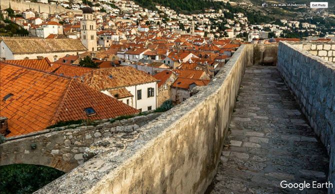
Google Earth is made for exploration and geographic discoveries. There are fascinating virtual tours on Google Earth.
So you can take a walking tour of Winterfell or jump to King’s Landing without murdering everyone in sight for the Iron Throne. The Game of Thrones virtual tour with 33 locations is one of the more fun activities you can do with the high-resolution satellite imagery on Google Earth.
It’s more scenic on Google Maps Street View, but Google Earth doesn’t lag behind with panoramic 360 degree tours too.
3. Measure Distances Big and Small
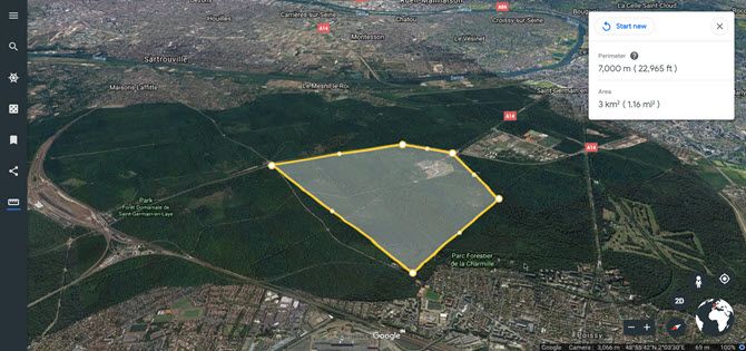
You are looking at the aerial view of your home on Google Earth. Maybe, now you would like to measure the plot of land it is standing on or calculate a nearby parcel you have your eyes on. Instead of manually stretching the tape, use Google Earth’s Measure Tool to do it in a few minutes.
On Google Earth Pro you can use lines and shapes to check distances and estimate elevations. For instance, you can use the elevation information to plan hikes around your countryside.
On Google Earth for Chrome, Android and iOS you can use the Measure Tool to calculate the perimeter or distance of between points on the map (see screenshot).
4. Use Historical View to Go Back to the Past
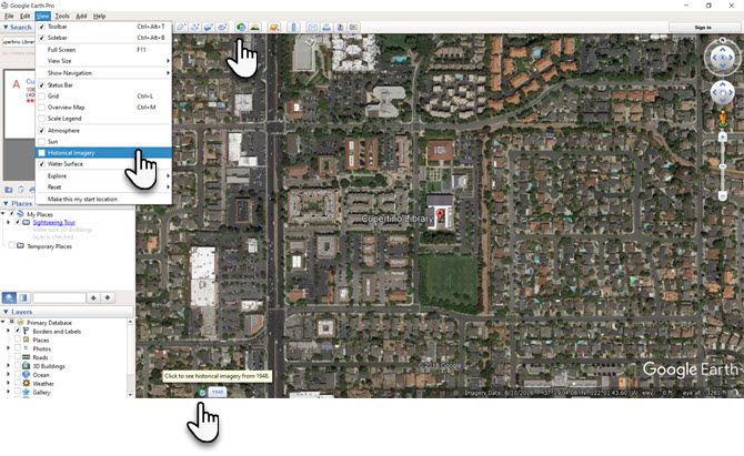
Google Earth Pro has a slider tucked away on the toolbar that works like a time machine. Imagine you are looking at the satellite view of your house or any other location and would like to see how it looked in the past. You can do three things to access historical imagery for the location.
- Go to the menu and select View > Historical Imagery.
- Click the Historical Imagery button on the toolbar (a clock with an arrow pointing counterclockwise).
- Click on the date in the lower left corner of the Google Earth window. Google Earth will jump to the oldest historical imagery available.
5. See a Satellite View of the Weather
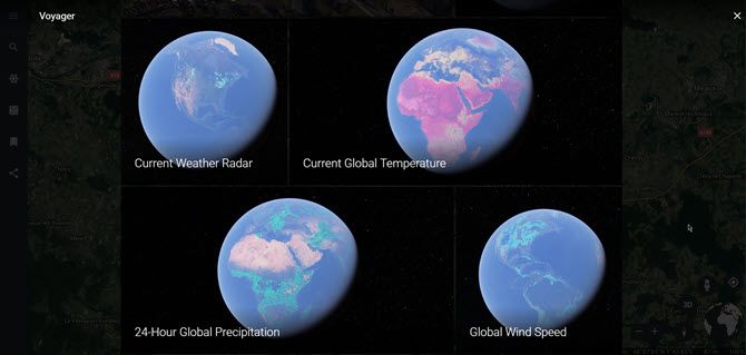
Did you know that you can look at weather patterns on a global scale on Google Earth? You can get near real-time data for temperature, wind speed, and precipitation.
- Open Google Earth for Chrome (also in Android or iOS).
- On the left panel, click the icon for Voyager.
- In the list of categories, click on Layers.
- Scroll down the tiles and choose Current Weather Radar. You can also click on other tiles like Current Global Temperature, Global Wind Speed, or 24-Hour Global Precipitation.
Combine it with Google Maps, and it may be the only weather app you need.
6. Monitor Natural Disasters in Near Real Time
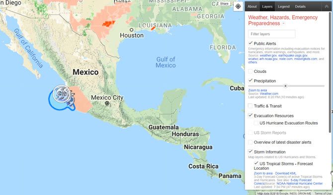
Google created a product called the Google Crisis Map to help people stay aware of developing natural disasters like hurricanes, storms, earthquakes, and more.
The crisis map uses Google Maps technology to make this information easily available in almost real time on any device with a browser. The crisis map also collates the information spread across multiple agencies and makes it easier to understand for the layman. Of course, it won’t offer you a satellite view of your house in real time but you can at least estimate the precautions you need to take as the disaster flows or ebbs.
You can use the crisis map as a standalone product or even download some layers as KML files to view them on Google Earth. For a more detailed walkthrough, head over to the Google Help Page.
Search Google Earth for the Best Views
Browsing Google Earth can be addictive. In fact, many creative uses have come out of this freewheeling browsing. For instance, Google Faces is an unofficial project that tries to spot “faces” hidden in the topography of our planet. Google Earth VR will soon enable you to take a virtual vacation.
For even more Google Earth fun, take a crack at these Google Maps games.
Read the full article: How to Get a Satellite View of Your House Using Google Earth
from MakeUseOf https://ift.tt/2EEvkSw
via IFTTT

Blockchain technology is the best answer for Crowdfunding apps. Here is a complete guide for How Blockchain is revolutionizing Crowdfunding app development?
ReplyDeleteRead Blog: Blockchain based Crowdfunding App Development